Talk to us
Have questions? Reach out to us directly.
Estuary Adaptation Project
View allWhat are the project goals?
The City’s Climate Action and Resiliency Plan (2019) includes an adaptation project for this northern shoreline area(PDF, 545KB) to protect the critical transportation infrastructure and the adjacent properties from a 100-year flood event and expected sea level rise. Any long-term solution involves working with multiple jurisdictions and agencies, and once fully funded could serve multiple functions as follows:
- Act as a barrier to the current 100-year coastal flood entry to the local streets, portals, tubes and State Route 260 on the Alameda side.
- Protect adjacent commercial and residential properties within the flood zone.
- Act as a barrier using a moderate sea level rise scenario.
- Become a Federal Emergency Management Agency (FEMA)-accredited project as a first step toward enabling the removal of the flood zone in the northern shoreline area.
What are the existing conditions?
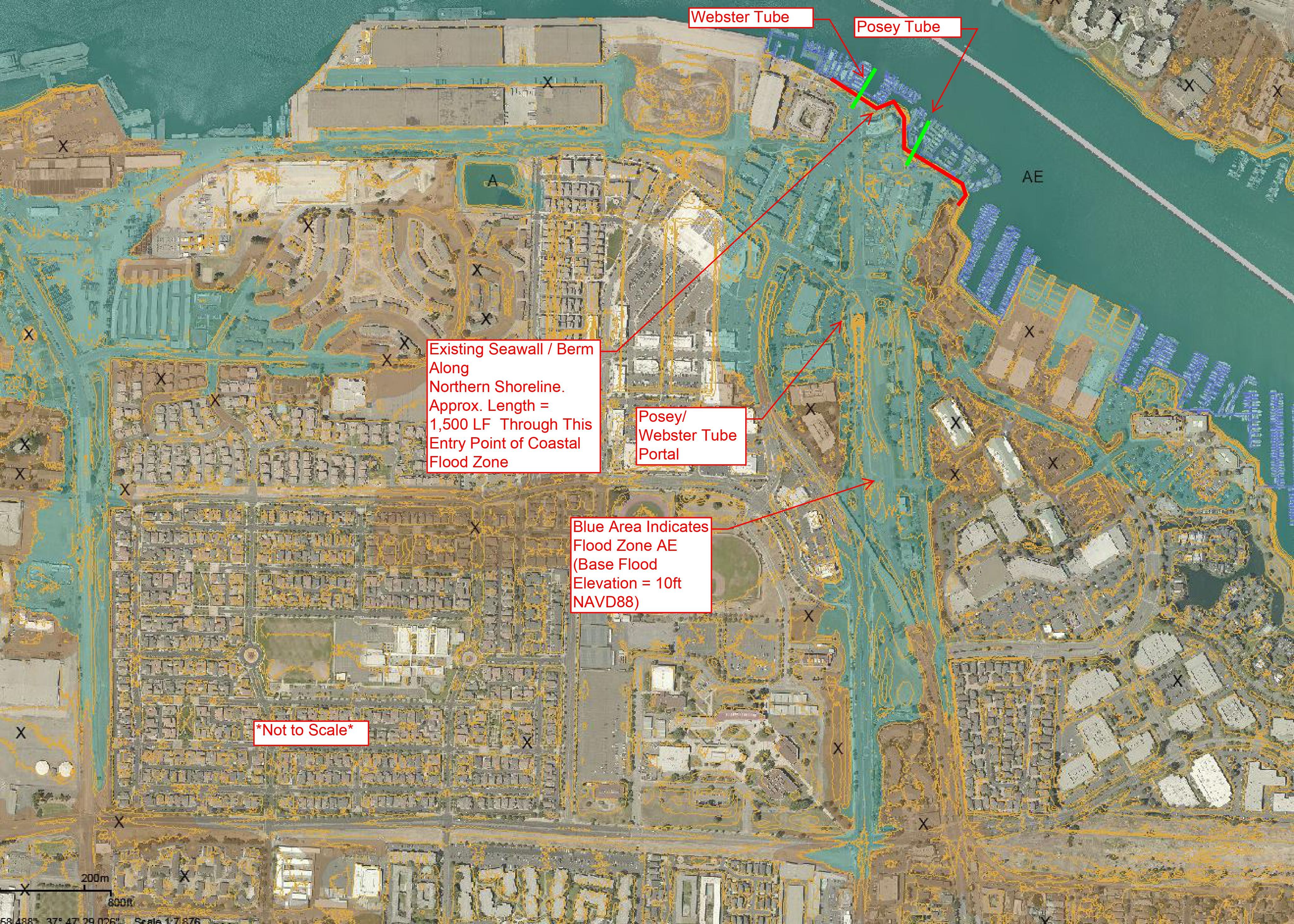
The current Federal Emergency Management Agency (FEMA) flood maps issued in December 2018 show the northern shoreline at the foot of Mariner Square Drive as an entry point for coastal flooding at the 100-year flood event. The map shown here(PDF, 446KB) depicts flooding in this area as well as in the Webster and Posey Tubes, State Route 260 and adjacent local streets, San Francisco Bay Trail and properties.
As one of the main thoroughfares for traveling between Oakland and Alameda, the Webster and Posey Tubes are located in the flood zone area created by the northern shoreline vulnerability. Both tube portal buildings and State Route 260, which runs through the tubes, Webster Street - extending south to Ralph Appezzato Memorial Parkway - and many commercial and residential properties also are included in this flood zone.
On the Oakland side, both portals and State Route 260 are located at a higher elevation than the 100-year flood zone. Therefore, the potential for coastal flooding of the Webster and Posey Tubes at the 100-year event or lower events would in all likelihood originate on the Alameda side. Nevertheless, any source of flooding from either side would impact both cities and would render the tubes impassible until resolved.
What are the expected future conditions with sea level rise?
The rate of sea level rise is dependent on global carbon dioxide emissions and other factors so it is not possible to determine exactly when the Bay will rise by a certain amount. Following guidance from the State of California, the City of Alameda is using a high tide elevation of 10 feet North American Vertical Datum (NAVD) 88, which is approximately 3.5 feet above today’s high tide for planning purposes to estimate future sea level rise.
The northern shoreline at the foot of Mariner Square Drive is likely to overtop due to sea level rise. Overtopping at this location is linked to projected inundation that is expected to extend along Webster Street and nearby roads and into the Webster and Posey Tubes as well as to adjacent commercial buildings and residential facilities.
What are the next steps?
The Webster and Posey Tube portals, Tubes and State Route 260 are all located in the Caltrans right-of-way and are maintained by Caltrans. City of Alameda staff are in discussions with Caltrans as well as the Alameda County Transportation Commission (Alameda CTC) regarding these vulnerabilities. There are currently no capital funds for a specific northern shoreline flooding/sea level rise adaptation project; however, the city is planning to pursue a grant opportunity that could lead to partial funding protective measures to bolster the seawall barrier to keep out bay water.
Status Update: Caltrans awarded a Sustainable Communities planning grant totaling $500,000 with local match to develop an adaptation project design concept for the Oakland-Alameda Estuary with community engagement and concept approvals by February 2025. Project Partners - consultant team, agency staff and Community Partners - are analyzing existing conditions/feasibility and preparing the community engagement strategy with the first round of community engagement expected in spring 2024. A second round of community engagement is expected in fall 2024 with recommendations completed in early 2025.
Image Gallery

Talk to us
Have questions? Reach out to us directly.

